Pictured Rock National Lakeshore
Saturday, July 15, 2000
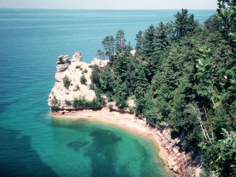
Pictured Rock National Lakeshore, on Michigan’s Upper Peninsula, encompasses 40 miles of sandstone cliffs, beaches, and dunes along Lake Superior’s southern shoreline. The name “pictured rock” comes from the colorful streaks of mineral stains that decorate the face of these colorful sculptured cliffs, which tower 50 to 200 feet above the aquamarine waters of Lake Superior. Erosion from the winds and the waves has sculpted these rocks over time, forming caves, arches, and formations resembling fortresses and castles.
The Pictured Rocks are best seen by boat or by air. However, if that is not an option, the best view of the rocks from land is from the Miners Castle Overlook, where there is an overlook platform directly above a castle-shaped formation in the cliffs. Another way to view the cliffs is to hike along the Lakeshore Trail, which runs the entire length of the park’s shoreline.
The only road through Pictured Rocks is an inland 40-mile sandy road that connects Grand Marais in the northeast with Munising in the southwest. Most of the shoreline itself is inaccessible by car, except for Miners Beach, Twelvemile Beach, and Hurricane River.
Activities at the Lakeshore include hiking, boating, kayaking, canoeing, fishing, and swimming in the somewhat chilly waters of Lake Superior.
Pictured Rocks has the unique distinction in my memory of containing both one of our all time vacation low points as well as one of our all time vacation highlights all within the span of one afternoon.
The day started off innocently enough with the scenic drive across the impressive 5-mile long Mackinaw Bridge into the Upper Peninsula of Michigan. Not knowing much about Pictured Rock, we headed to the visitor center in Grand Marais at the east end of the park to get some information and ideas as to what to see and do. The good news was the Lakeshore contained 40-miles of Lake Superior shoreline with colorful sculptured cliffs (“picture rocks”) rising 50 to 200 feet above the lake. The bad news was there were only 3 points along the shoreline that you could get to by car, and they were only reached via the 30-mile long sandy road that ran from the eastern end of the park.
We really didn’t want to come all this way without seeing the pictured rocks so we decided to take the unpaved road. Our goal was to get to Miner’s Beach on the west end of the Lakeshore to at least see the pictured rocks and hopefully either swim or launch our inflatable boat to get a better view of the cliffs. We knew our chances of boating were slim because Lake Superior is more like an ocean than a lake, and usually not the place for a small boat such as ours.
The road didn’t start off too bad—that was just its evil way of luring us into complacency until it was too far to turn back. For awhile, we were able to bounce along at about 20 mph on the hard packed sand. About 10 miles into our journey, the road worsened becoming a continuous series of washboard-like bumps, causing everything that wasn’t bolted down in the RV to bounce around madly. We had to reduce our speed to 5 mph. I remember following our route on the map on our laptop/GPS setup and watching the excruciatingly slow progress of the little arrow (that represented our motor home) moving along our planned route. I eventually had to turn the laptop off because the jarring was risking doing damage to our hard drive. Four agonizing hours later, with nerves completely shattered, we reached the pavement near the turnoff for Miner’s Beach. By this point, Herb hated this park so intensely, that it took some convincing to get him to spend even one more minute here and drive down the short paved road to the Miners Castle Overlook.
He was fried. He didn’t even want to get out of the motor home to the see the cliffs. The kids and I walked out to the fenced-in overlook and got our first glimpse of the “pictured rock” cliffs dropping off into the aquamarine waters of Lake Superior, which were uncharacteristically like a sheet of glass. It was an awesome sight. As Herb reluctantly approached the overlook, I turned to him and said, “You’re gonna wanna launch the boat,” which has since become our rallying cry whenever we see spectacular rivers, lakes, or oceans to launch our boat in.
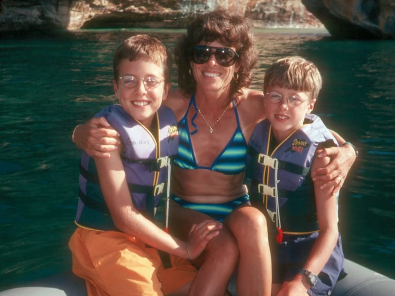
I think Pictured Rocks was trying to make up for the ordeal it put us through by giving us the gift of calm waters so that we could explore the cliffs in our inflatable. We lost no time. We quickly drove down to the Miners Beach to set up.
We had packed our12-foot Avon inflatable raft and 6 hp motor on this trip in the hopes that we would come across some opportunities to use it. The raft was stored in a big bag at the foot of the kids’ bed over the cab, the wooden floorboard was stored next to the refrigerator, and the 6 hp motor was attached to the back ladder of the RV often eliciting inane comments from strangers, such as, “Can that little motor really power this big vehicle,” as if we were some kind of Magic School Bus.
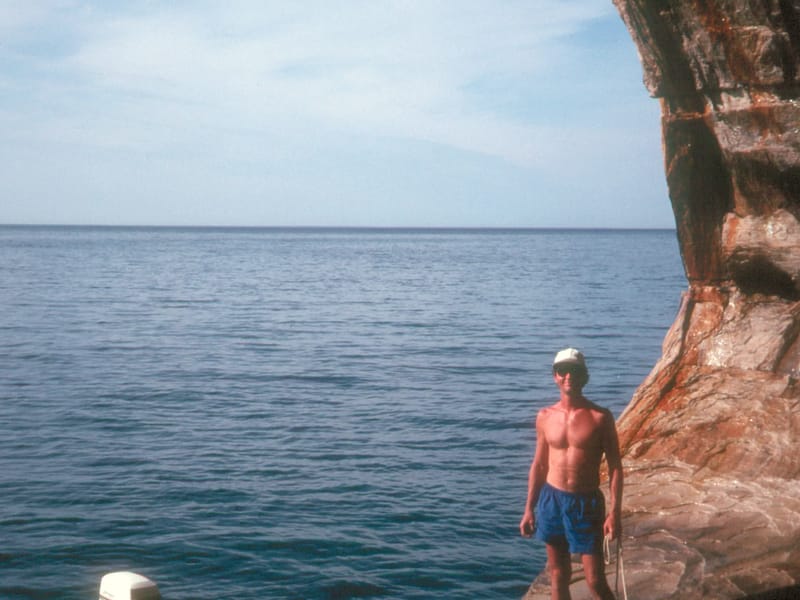
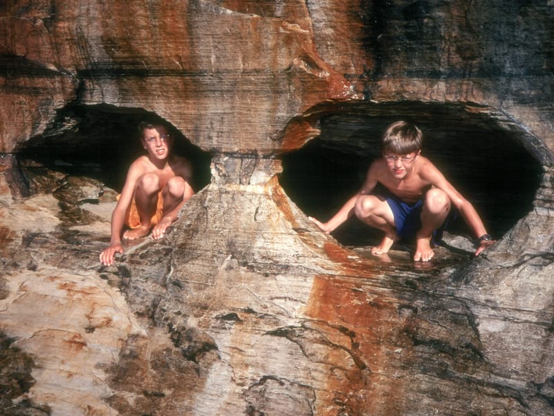
Like a precision team, desperate to extract some fun from the depths of despair, we setup and launched the raft in under a ½ hour. We putted happily along a 4-mile stretch of the pictured rocks between Miner’s Castle, a beautiful rock formation in the shape of a castle, and Mosquito Beach. Along the way, we cruised through arches carved out of the cliffs, stopped in caves, and experienced some of the best views the park had to offer. At Mosquito Beach we splashed around in the waters where the Mosquito River flowed into Lake Superior. It was a fabulous experience—worth every bounce along our way here.
Back at Miners Beach while putting away the raft, the fickle Pictured Rocks tried to turn on us again. Our first suspicion that something bad was coming was the approach of a couple strolling along the beach clothed in full mosquito netting from head to toe. How ridiculous we all thought, but as dusk approached we ate our words. We became so covered in mosquitoes that we could barely carry the raft back to the RV because we had to constantly stop to slap the mosquitoes off.
However, not even the mosquitoes could put us in a bad mood after the great day we had had out on the lake.
What We Did
- Sable Falls
Sable Falls
- Pictured Rocks
Pictured Rocks
- Bay Furnace Campground
Bay Furnace Campground
- Pictured Rock National Lakeshore
Pictured Rock National Lakeshore
- Lake Superior
Lake Superior