Capitol Reef National Park
Thursday, July 21, 2005
Capitol Reef National Park in south central Utah is much less well known and therefore much less crowded than most of Utah’s other national parks, such as Zion and Bryce. However, this undiscovered treasure offers some of the most spectacular scenery in Utah.
The park’s central geological feature—the Waterpocket Fold- was formed more than 70 million years ago when forces within the earth began to uplift, squeeze, and fold dozens of rock formations into a giant 100-mile long wrinkle in the Earth’s crust. It was named Waterpocket because of the many pools of water that get trapped in the tilted strata. Brilliantly colored rock spires, domes, canyons, and arches were carved out of the fold by millions of years of erosion.
Capitol Reef was named by explorers who found the cliffs of the Waterpocket Fold to be a barrier to their travel west. Many of these explorers had been seafaring men, so the rock barriers reminded them of an ocean “reef” blocking ocean travel. The rounded sandstone domes in the park reminded them of the domes on “capitol” buildings; hence the name Capitol Reef.
In stark contrast to the brilliant cliffs and barren desert of the park is the lush oasis of cottonwood, willow, and ash trees along the banks of the Fremont River. In the 1880’s, Mormon pioneers established the community of Fruita here and planted orchards along the river’s rich banks. These orchards, as well as a schoolhouse, blacksmith shop, and the Behunin Cabin, have been preserved here by the National Park Service. There is a campground and picnic area here as well.
Other evidence of much earlier human habitation can be found in the thousand-year-old petroglyphs left behind by the ancient Fremont and Anasazi people.
From Route 24, which crosses Capitol Reef National Park from east to west, you can see some of the park’s best features, such as Capitol Dome, Chimney Rock, the Fruita Schoolhouse, and the roadside petroglyphs.
If you have more time, drive the paved 25-mile roundtrip scenic drive, which has excellent views of the dramatic canyons and rock formations of Capitol Reef. At the end of the scenic drive is the gravel Capitol Gorge Road, a 5-mile loop with what many think is the best scenery in the park.
We had been to Capitol Reef before, but hadn’t really done it justice. During that first visit, the scenic road was closed because of flashfloods, so all we did was drive through the park on Route 24, stopping at some of the sights along the way. Nice, but nothing that really stood out for me. This time, however, was really different, and I have come to truly love the beauty of Capitol Reef.
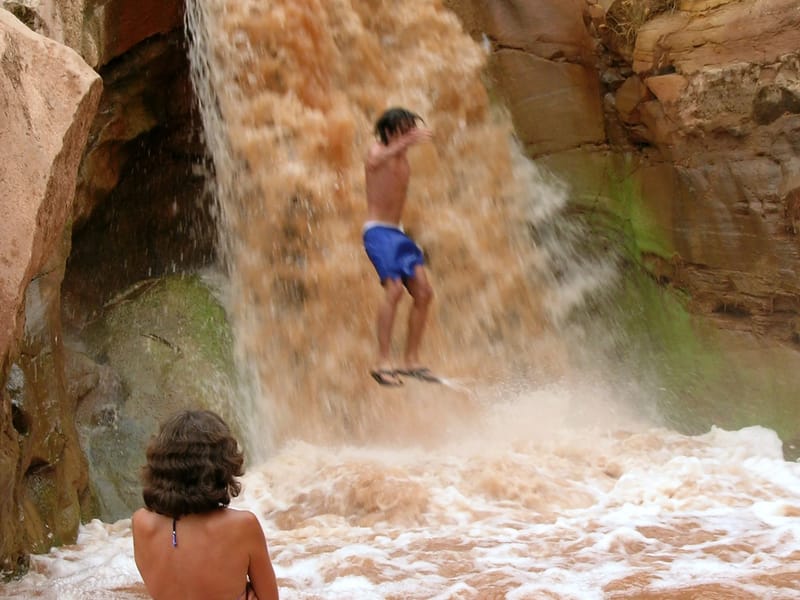
It started off on a high note with what would become one of our trip highlights. As we were driving west along Route 24 towards the Visitor Center, Herb noticed a bunch of cars parked on the side of the road. He glanced over and just barely caught sight of a beautiful waterfall cascading over the red rocks to our right. We could very easily have missed it. In fact, the last time we were here, we did. Perhaps it was because we were driving in the opposite direction and would have had to look back to see it. There was absolutely nothing written up about it in any of the guidebooks or the park brochure.
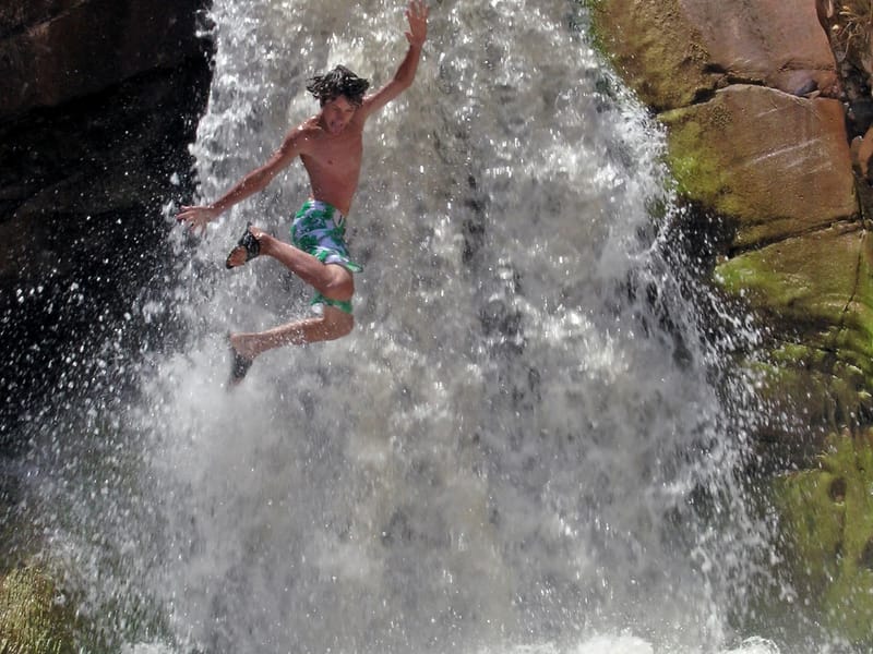
We parked the RV and climbed down a path through some bushes to the base of the falls where we found a group of people having a great time swimming in the pool under the falls. We quickly joined them. It was delightful. The falls were about 20 feet high and quite powerful. We really had to fight to get underneath them as the force of the pounding water pushed us away. It was exhilarating. The boys followed some other brave souls up the slippery rocks alongside the falls and then jumped into the middle of them. Thanks to digital photography, we got some great mid-air shots of them flying through the spray.
After about an hour, we reluctantly left the falls and headed towards the main part of the park. Capitol Reef didn’t owe us anything from this point. It had already far exceeded our expectations, and we hadn’t even gotten to the main part of the park yet.
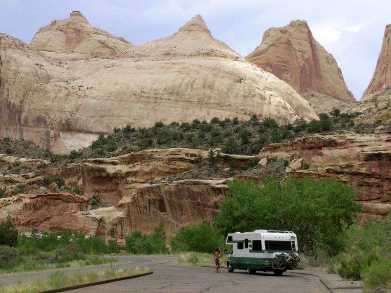
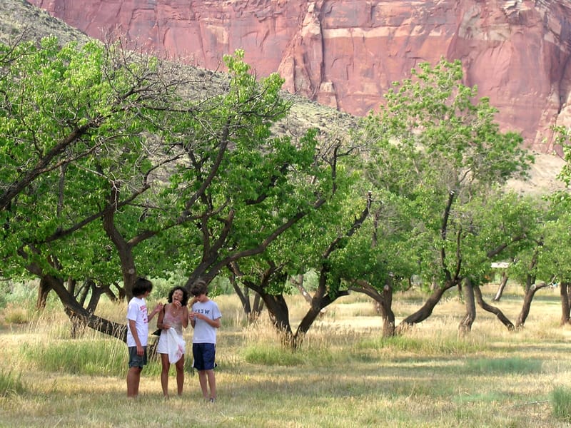
When we arrived at the Fruita Campground, just a short distance past the Visitor Center, we knew right away that we had to spend some time here - at least a night or two. I do love the stark beauty of the desert, but the greenness of this campground and the flowing water of the Fremont River were a very welcome respite. It was great! There were actually trees, and there were acres of fruit orchards right next to the campground where you could wander and pick fruit.
For some reason, the kids just couldn’t wait to do some fruit picking. I’ve never seen them display such a strong interest in fruit before, but I guess it was the novelty of using the long fruit picking sticks that intrigued them. They were hoping for peaches or apples, but they had to make do with apricots because that was the fruit currently in season. I don’t think they even knew what an apricot looked like, much less tasted like, but they were still pretty enthused. They know how to make a good time out of practically anything we do, which is quite refreshing, especially considering they’re teenagers. The trees had been picked pretty bare already, but we had fun anyway and did manage to collect a few good ones.
Our campsite was great—plenty of room between neighbors and great views of the red rock cliffs across from us. We set out our beach chairs and just relaxed for awhile, but not for too long. There were too many things to do.
That evening we hiked the Fremont River Trail, which was recommended by the park ranger as the best hike to take at sunset. She was right. The trail started right from the campground and meandered through the orchards along the river—it didn’t feel like we were in Utah at all. After about ½ mile, the trail climbed quite steeply for another ¾ mile or so up to a lovely overlook above the river and valley. We would have spent a lot more time up there enjoying and photographing the view if it hadn’t been for the thunderclouds that were swiftly moving towards us. With the wide open skies out west, you can really see a thunderstorm coming. We scurried back down to the campground in time to avoid the storm.
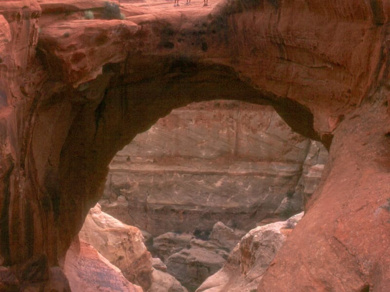
The next morning was Tommy’s 14th birthday—his fifth to be celebrated on the road. He had spent his 9th birthday having lunch at the beautiful Prince of Wales Hotel in Waterton-Glacier National Park, his 10th mountain biking down Whistler-Blackcomb Mountain in British Columbia, his 12th rafting down the Colorado River near Moab, and his 13th on beautiful Newfoundland. Needless to say, he had expectations. I think he would have liked to spend his birthday at an amusement or water park, but that was not really an option in this part, or probably any part, of Utah. So we broke him the good news. For his special day, we had a sort of biathlon planned—a 3 ½ mile bike ride to the end of the Grand Wash Road, followed by a 3 ½ mile strenuous hike to the top of Cassidy Arch (where Butch Cassidy supposedly hid out), and then, of course, the 3 ½ mile ride back to the campground. He tried to control his enthusiasm.
The bike ride portion consisted of about 2 miles on the hilly but paved scenic drive, and then another mile or so on the unpaved Grand Wash Road. The boys liked the unpaved part where they invented a new riding style—stomachs on the bike seat and legs straight out behind them like superman. The only body part in the right place was their hands on the handlebars.
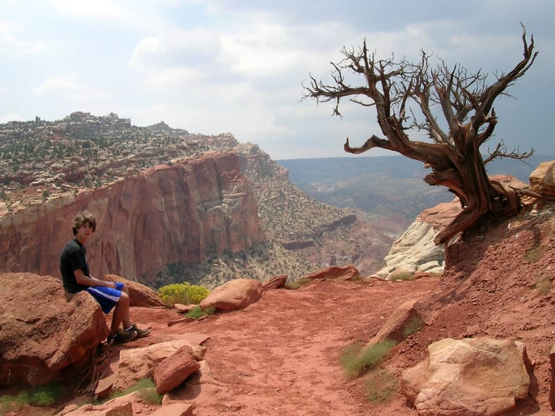
At the end of the Grand Wash Road, we locked our bikes up and started the hiking portion of the day. The hike began at the floor of the Grand Wash—a place you probably didn’t want to be at after a big rain—and climbed steeply to the top of high cliffs overlooking the park. It was pretty strenuous. About half way up, we began to hear thunder rumbling in the distance. Tommy, always the most sensible of all of us, wanted to turn back. The rest of us really wanted to get to the Arch—three against one. We practically ran the rest of the way up the steep trail, hoping to beat out the storm. By the time we got to the top, the storm was really close. The kids and I quickly ran out on top of the arch so Herb could photograph us, but it was getting pretty scary. The rain was starting and the time between the lightning and the thunder was getting closer and closer. Poor Herb never even got a chance to go out on the Arch, which, by the way, looked a lot scarier from the photos than it was. It really is pretty wide—even by my wimpy standards. A heated debate began as to what we should do. Some of us wanted to find shelter under a rock overhang and wait out the storm. Herb suggested we get out of there as soon as possible. There was no telling how long the storm would last, and the slick rock that we had climbed to get here was only going to get slipperier with more rain. Tom was mad we were in this position at all and mentioned something about bad parenting. We decided to go with Herb’s plan and started to run, probably breaking the record for the quickest descent of this trail. We ran the whole way. Back at the bottom, we jumped on our bikes and pedaled as fast as we could through the muck on the Grand Wash Road. The mud was shooting up from our tires and painting a stripe on our backs. By the time we got back to the campground, the storm had subsided and the sun was beginning to peek out. We, however, were a mess. Tommy wouldn’t even speak to any of us for the next couple of hours.
Now that the sun was back out, we decided to return to the waterfall, hoping to have the same great experience as the day before, and possibly get Tommy to speak to us again. What a difference a day makes. The falls looked completely different. When it rains around here, that beautiful red sand and rock that I love so much gets washed right along with the runoff. Our crystal clear waterfall from the day before was now a cloudy red. They all made fun of me when I said that the falls looked liked a salmon fillet, but it did. It wasn’t nearly as inviting to swim in as the day before. I wonder how long it takes it to return to clear. Tommy eventually forgot he was mad at us and started speaking to us again. It was good to have him back.
When we got back to the campground, Herb had us switch sites to the other side of the campground where we had an even better view of the cliffs. Herb doesn’t ask for much on these trips and usually lets me run the show, but the one thing that he is obsessed with is being able to sit back in his chair in the evening after a hard day of having fun, cocktail in hand and great scenery all around him. Well, he got it. Last night’s view wasn’t too shabby, but this one was spectacular.
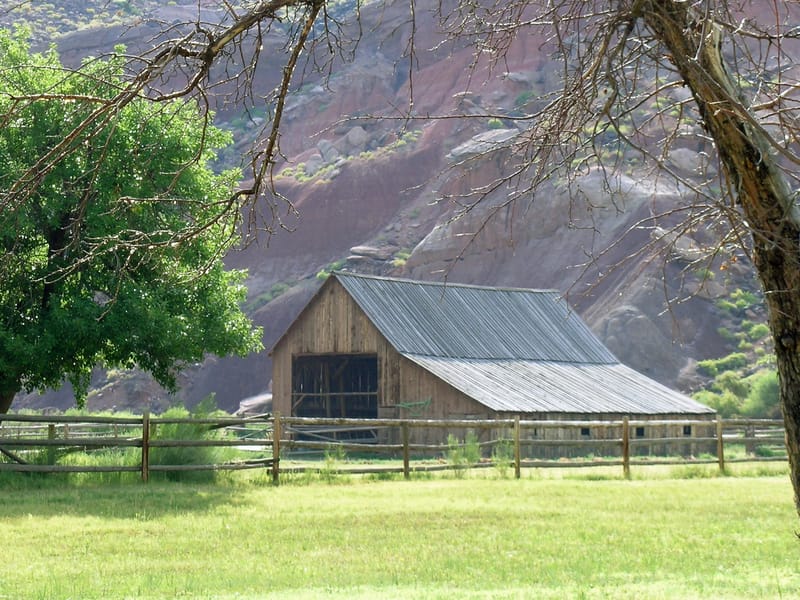
Also, we were now next to the Gifford house, an early 1900s Mormon farmhouse, which was quite picturesque. The Fruita area was first settled by Mormon pioneers in the 1880s, who were attracted to this area because of its fertility and potential for orchards. Speaking of fertility, records show that these first settlers were Mormon polygamists seeking refuge from the Federal government’s enforcement of anti-polygamy laws.
I usually like to know about the history of places we visit, but I realized that I didn’t know much at all about the Mormon faith and the role that polygamy plays in their religion. Since our trip, I have read Jon Krakauer’s book [amazon 1400032806], which gives an interesting and frightening account of the history of Mormon Fundamentalism. The main Mormon Church stopped practicing polygamy a long time ago, but a group of extremists, or Fundamentalists, have broken away from the main church and are still practicing it today in various parts of Utah and northern Arizona. It was kind of creepy to think that these things were going on in modern-day America and not very far from where we traveled.
The next morning before we left, we spent some time photographing the Gifford homestead. Andrew was still working on shooting those 5 rolls of black and white film for his summer photography assignment. I think he got some good shots. One of them was of a pair of red long johns hanging on the laundry line outside the farmhouse. He was hoping to print it in black and white and then hand-color the long johns red. I think that will be a pretty interesting effect.
Well, it was time to leave Capitol Reef and head to another one of our favorite places- Moab, Utah. I’m really glad we got to see more of Capitol Reef this time though. It’s a very special and unique place, and one that I will definitely want to come back to.
What We Did
- Waterfall
Waterfall
- Scenic Drive
Scenic Drive
- Fremont River Trail
Fremont River Trail
- Grand Wash Road
Grand Wash Road
- Cassidy Arch
Cassidy Arch
- Fruita Campground
Fruita Campground
- Gifford Farmhouse
Gifford Farmhouse